Browse Items (21 total)
- Tags: right of way
Wabash Railroad Right of Way and Track Map - 27th St. Through Lake Decatur (7/1/1953)
Tags: #8.003, 1953, 24th St., 25th St., 26th St., 27th St., 29th St., 31st St., 32nd St., 33rd St., 34th St., 35th St., 7/1/1953, A.E. Staley Manufacturing Co., additions, businesses, Camp and Emrich Addition of outlots, Camp and Emrich's 2nd Addition of outlots, collection, Decatur IL, Donovan Heights Addition, E. Division St., E. Grand Ave., E. Hickory St., E. Locust St., E. Logan St., E. Olive St., Faries Parkway, Fern Ct., Garden Place, Garfield Ave., Geddes Ave., Hillcrest Dr., Homewood Ave., ISHRAB-2017-25-93, James St., Lake Decatur, Lakewood Ave., map, Maps, Office of Chief Engineer, public road, Raceland Plat "C" in Plat "C", Raceland Plat "D" in Plat "A", Railroad Map Collection, right of way, right of way and track map, Samuels St., Spencer-Kellogg & Son Co., State Route 47, Streets, Track, track map, Tracks, Wabash Railroad, Wabash Railway, Wabash RR, Wabash yards, West Lake Addition outlots, Yards
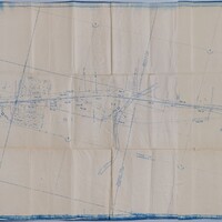
Wabash Railway Right of Way and Track Map - From Wyckles Land in Harristown Township to N. Mercer St. (6/30/1919)
Tags: #8.003, 1919, 6/30/1919, Ashland Ave., Cobb Ave., collection, Decatur IL, Decatur Township, Dennis Ave., Dunham St., E-Z Opener Bag Co., Fair Lawn Ave., Fairlawn Cemetery, Fairview Park, Harristown Township, Home Ave., Ice Plant, Illinois Terminal System, Illinois Traction System, ISHRAB, ISHRAB-2017-25-82, ITS, map, Maps, McClelland Ave., N. Fairview Ave., N. Mercer St., N. Oakland Ave., N. Pine St., Oakdale Bl., Office of Chief Engineer, Park Place, Prairie Ave., Railroad Map Collection, right of way, right of way and track map, roadway, Summit Ave., Taylor Ave., Track, University Ave., Van Dyke St., Victoria Ave., W. Cerro Gordo St., W. Eldorado St., W. Green St., W. King St., W. Marietta St., W. North St., W. Packard St., W. William St., Wabash, Wabash Railroad, Wabash Railway, Wabash RR, Westlawn Ave., Woodlawn Ave., Wyckles, Wyckles land, Wyckles plat
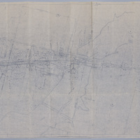
Wabash Railway Right of Way and Track Map - From the Yards to the West of the Sangamon River (6/30/1919)
Tags: #8.003, 13th St., 14th St., 15th St., 18th St., 1919, 6/30/1919, additions, Camp and Emrich Addition of outlots, Camp and Emrich's 2nd Addition of outlots, Clarence Ave., collection, Decatur IL, Decatur Township, E. Division St., E. Grand Ave., E. Locust St., E. Logan St., E. Olive St., Hickory St., Illinois Traction System, ISHRAB, ISHRAB-2017-25-90, ITS, James St., Long Creek Township, map, Maps, Moser Road, Oakley Township, Office of Chief Engineer, Orchard St., Raceland Plat "C" in Plat "C", Raceland Plat "D" in Plat "A", Railroad Map Collection, right of way, right of way and tracks map, Sangamon River, Streets, Thomas Ave., Tracks, Wabash, Wabash Railroad, Wabash Railway, Wabash RR, Wabash yards, Westlake 2nd Addition of outlots, Westlake Addition of Outlots, Yards
Wabash Railway Right of Way and Track Map - Wyckles to N. Mercer St. (6/30/1919)
Tags: #8.003, 1919, 6/30/1919, Ashland Ave., Cerro Gordo St., Cobb Ave., collection, Decatur IL, Decatur Township, Dennis Ave., Dunham St., Fairlawn Ave., Fairlawn Cemetery, Fairview Park, Harristown Township, Home Ave., Illinois Traction System, ISHRAB, ISHRAB-2017-25-112, ITS, map, Maps, McClelland Ave., N. Fairview Ave., N. Mercer St., N. Oakland Ave., N. Pine St., Oakdale Ave., Office of Chief Engineer, Park Place, Prairie Ave., Railroad Map Collection, right of way, right of way and track map, Streets, Summit Ave., Taylor Ave., Track, University Ave., Van Dyke St., Victoria Ave., W. Eldorado St., W. Green St., W. King St., W. Main St., W. Marietta St., W. North St., W. Packard St., W. William St., Wabash, Wabash Railroad, Wabash Railway, Wabash RR, Westlawn Ave., Woodlawn Ave., Wyckles
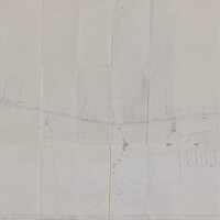
Wabash Railway Right of Way and Track Map - South of Rock Springs Rd. to Jackson St. (6/30/1919)
Tags: #8.003, 1919, 6/30/1919, Bridge, Bright St., Church St., collection, College St., Cottage Hill Ave., Decatur IL, Dunham St., Edward St., Fairview Ave., Fairview Rd., Haworth Ave., Home Ave., ISHRAB, ISHRAB-2017-25-125, Knights, Lincoln Park Dr., map, Maps, McClelland Ave., N. Franklin St., N. Jackson St., N. Main St., N. Mercer St., N. Monroe St., N. Oakland Ave., N. Pine St., N. Water St., Oakland Ct., Office of Chief Engineer, railroad, Railroad Ave., Railroad Map Collection, right of way, right of way and track map, Rock Springs Rd., S. Oakland Ave., Sangamon River, St. Louis Bridge, St. Louis Bridge Rd., State Route 48, State Rt. 48, Sunset Ave., Sycamore Ave., Track, Union St., University Ave., Van Dyke St., W. Cerro Gordo St., W. Decatur St., W. Eldorado St., W. Forest Ave., W. Green St., W. King St., W. Macon St., W. Main St., W. North St., W. William St., W. Wood St., Wabash, Wabash Railroad, Wabash Railway, Wabash RR, Willow Ave.
Right of Way and Track Map - Cincinnati, Indianapolis, and Western RR, Operated by Baltimore and Ohio Railroad Company (6/30/1918)
Right of Way and Track Map - Cincinnati, Indianapolis, and Western RR, Operated by the Baltimore and Ohio Railroad Company (6/30/1918)
Tags: #8.003, 1918, 6/30/1918, Allen Travis, Ambrose Greenfield, B&O, Baltimore and Ohio Railroad Company, Cincinnati Indianapolis and Western RR, collection, Henry W. Davis, ISHRAB-2017-25-12, James Millikin, John S. Kiser, land plats, Long Creek IL, Maps, N.L. Prather, railroad, Railroad Maps Collection, right of way, Samuel M.C. Davis, State Road 36, Track
Right of Way and Track Map - Cincinnati, Indianapolis, and Western RR, Operated by the Baltimore and Ohio Railroad Company (6/30/1918)
Tags: #8.003, 1918, 6/30/1918, B&O, Baltimore and Ohio Railroad Company, Cincinnati Indianapolis and Western RR, I.Q.A Odor, ISHRAB-2017-25-13, John W. Tyler, Long Creek IL, Long Creek Township, Miller S. Fietrow, Nathan N. Baker, Office of Valuation Engineer, railroad, Railroad Map Collection, right of way, Samuel B. Wortman, Samuel M.C. Davis, Samuel W. Gillespie, State Road 121, Sylvester C. Davis, Track, W.M. Davis
Right of Way and Track Map - Cincinnati, Indianapolis, and Western RR, Operated by the Baltimore and Ohio Railroad Company (6/30/1918)
Tags: #8.003, 1918, 6/30/1918, Aaron Ruth, collection, Decatur Township, Euclid Broadwell, ISHRAB-2017-25-22, ISHRAB-2017-25-23, Jacob Stickle, John Garver, Joseph Spangler, Lake Decatur, Long Creek Township, map, Michael Eichinger, Michael Elson, Miller S. Fetrow, Nelson Park Drive, railroad, Railroad Map Collection, right of way, right of way and track map, Track, W.M. Davis, Wm. Deweese, Wm. Prather
Cincinnati, Indianapolis & Western RR Right of Way and Track Map - Fairview Ave to Franklin St. (6/30/1918 - Revised 6/7/1959)
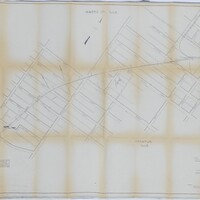
Tags: #8.003, 1918, 1959, 6/30/1918, 6/7/1959, B&O, Baltimore & Ohio Railroad Company, Bright St., Cerro Gordo St., Church St., CI&W RR, Cincinnati Indianapolis & Western RR, collection, College St., Cottage Hill Ave., Decatur IL, Edward St., Fairview Ave., Haworth Ave., Home Ave., ISHRAB, ISHRAB-2017-25-9, map, Maps, Mason St., N. Main St., N. Mercer St., N. Monroe St., N. Pine St., N. Water St., Office of Valuation Engineer, Railroad Map Collection, revised, right of way, right of way and track map, S. Franklin St., S. Oakland Ave., Sangamon River, St. Louis Bridge, Streets, Sunset Ave., Track, Union St., Van Dyke St., W. Decatur St., W. Eldorado St., W. Forest Ave., W. Green St., W. King St., W. Macon St., W. Main St., W. North St., W. William St., W. Wood St., Wabash, Wabash Railroad, Wabash Railway, Wabash RR
