Search using this query type:

Search only these record types:


Advanced Search (Items only)

Decatur Public Library Local History Photo Collection
  • Browse Items
  • Browse Collections
  • Browse Exhibits
  • Finding Aids
  • About
  • Contact Us

Browse Items (1 total)

  • Tags: ISHRAB-2017-25-93
    • Browse All
    • Browse by Tag
    • Search Items
Sort by:
  • Title
  • Creator
  • Date Added

Wabash Railroad Right of Way and Track Map - 27th St. Through Lake Decatur (7/1/1953)

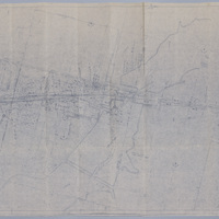
This right of way and track map shows the Wabash Railway tracks going east from 27th St. over Lake Decatur.

Tags: #8.003, 1953, 24th St., 25th St., 26th St., 27th St., 29th St., 31st St., 32nd St., 33rd St., 34th St., 35th St., 7/1/1953, A.E. Staley Manufacturing Co., additions, businesses, Camp and Emrich Addition of outlots, Camp and Emrich's 2nd Addition of outlots, collection, Decatur IL, Donovan Heights Addition, E. Division St., E. Grand Ave., E. Hickory St., E. Locust St., E. Logan St., E. Olive St., Faries Parkway, Fern Ct., Garden Place, Garfield Ave., Geddes Ave., Hillcrest Dr., Homewood Ave., ISHRAB-2017-25-93, James St., Lake Decatur, Lakewood Ave., map, Maps, Office of Chief Engineer, public road, Raceland Plat "C" in Plat "C", Raceland Plat "D" in Plat "A", Railroad Map Collection, right of way, right of way and track map, Samuels St., Spencer-Kellogg & Son Co., State Route 47, Streets, Track, track map, Tracks, Wabash Railroad, Wabash Railway, Wabash RR, Wabash yards, West Lake Addition outlots, Yards

  • Browse Items
  • Browse Collections
  • Browse Exhibits
  • Finding Aids
  • About
  • Contact Us
Decatur Public Library
130 N. Franklin St.
Decatur, IL 62523
(217) 424-2900

The Decatur Public Library owns and maintains all copyright on materials featured on omeka.decaturlibrary.org. These materials cannot be used without prior consent. Please contact the Archives and Special Collections Department at the Decatur Public Library for more information.

Proudly powered by Omeka.