Search using this query type:

Search only these record types:


Advanced Search (Items only)

Decatur Public Library Local History Photo Collection
  • Browse Items
  • Browse Collections
  • Browse Exhibits
  • Finding Aids
  • About
  • Contact Us

Browse Items (2 total)

  • Tags: Illinois Power Company
    • Browse All
    • Browse by Tag
    • Search Items
Sort by:
  • Title
  • Creator
  • Date Added

Map of Decatur & Environs Showing the Norfolk & Western Railroad (3/1968)

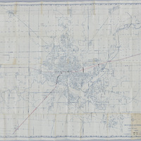
This is a map of Decatur and the surrounding area, showing the Norfolk & Western Railroad in red. The grade crossings and grade separation are marked as well.

Tags: #8.003, 1968, 6/1968, B&O, Baltimore & Ohio Railroad, collection, Decatur IL, grade crossing, grade separation, ICRR, Illinois Central Railroad, Illinois Power Company, ISHRAB-2017-25-1, Macon County IL, map, map of Decatur & Environs, Maps, N&W, Norfolk & Western Railroad, railroad, Railroad Map Collection

Railroad Index Map (7/10/1990)

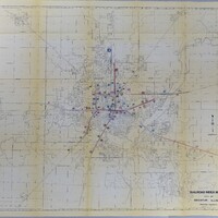
This is a railroad index map of Decatur, IL showing the different railroads that came through the city.

Tags: #8.003, 1990, 7/10/1990, collection, Decatur Blue Print Company, Decatur IL, Illinois Power Company, ISHRAB, ISHRAB-2017-25-141, Macon County, map, Maps, railroad, railroad companies, railroad index map, Railroad Map Collection

  • Browse Items
  • Browse Collections
  • Browse Exhibits
  • Finding Aids
  • About
  • Contact Us
Decatur Public Library
130 N. Franklin St.
Decatur, IL 62523
(217) 424-2900

The Decatur Public Library owns and maintains all copyright on materials featured on omeka.decaturlibrary.org. These materials cannot be used without prior consent. Please contact the Archives and Special Collections Department at the Decatur Public Library for more information.

Proudly powered by Omeka.