
Browse Items (110 total)
- Collection: Railroad Map Collection #8.003
Sort by:
Partial Map of the Illinois Central Railroad Belt Line along W. McKinley St. (N/D)

This map shows the Illinois Central Railroad belt line along W. McKinley St. down to the PD&E Railway at Harrison Ave. This belt line connected the Peoria branch of the ICRR to the main line. The date is unknown on this map. This map attaches to…
Partial Map of the Wabash Railroad Office Building - Showing Jordan St.

This is a partial map of Jordan St. in Decatur, IL. On the back of the map, it says that this partial map is part of a map of the Wabash RR's office building.
Pennsylvania Lines - Proposed Extension of Side Track for the Shellabarger Elevator Co. & Re-arrangement of Tracks in Marietta St. Yard (12/6/1919)

This map shows the proposed side track extension of the Pennsylvania Lines for the Shellabarger Elevator Co., and the re-arrangement of the Marietta St. yards.
Pennsylvania Railroad Company Side Track Agreement with McClelland Grocer Co., Nafziger Baking Co., James M. Allen, & Grace S. Allen (2/18/1926)

This is the side track agreement between Pennsylvania Railroad Company, McClelland Grocer Co., Nafziger Baking Co., James M. Allen, and Grace S. Allen. It includes a map of the side track and the signed agreement.
Plat Map of Portion of Peoria, Decatur & Evansville Railroad - Illinois Central Railroad (1921)

This is a plat map of a portion of Peoria, Decatur & Evansville Railroad, operated by Illinois Central Railroad. It shows the track between W. Marietta St. and W. Green St.
Profile of the Illinois Traction Inc. Decatur Belt Line (6/17/1925)

This shows the profile of the Decatur belt line of the Illinois Traction Inc. The profile shows the elevation of the tracks, what streets it crossed, and what other railroads it crossed.
Railroad Index Map (7/10/1990)
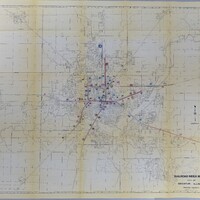
This is a railroad index map of Decatur, IL showing the different railroads that came through the city.