
Browse Items (13 total)
Sort by:
Photos of 200 Block W. Main St.
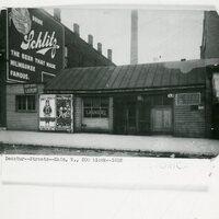
Photographs of the 200 Block of W. Main St, 1912. Photographs of the 200 Block of W. Main looking east toward Lincoln Square, photo by Wasson Studios, c. 1910. Photograph of City paving W. Main from Church. "Riding the street cars was about the only…
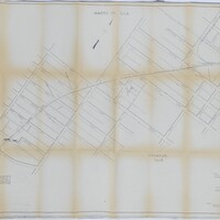
Wabash Railway Right of Way and Track Map - South of Rock Springs Rd. to Jackson St. (6/30/1919)

This right of way and track map shows the Wabash railroad track from south of Rock Springs Rd. to N. Jackson St.
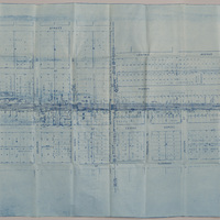
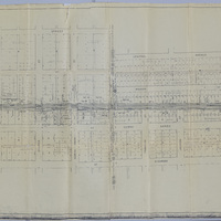
Profile of the Illinois Traction Inc. Decatur Belt Line (6/17/1925)

This shows the profile of the Decatur belt line of the Illinois Traction Inc. The profile shows the elevation of the tracks, what streets it crossed, and what other railroads it crossed.
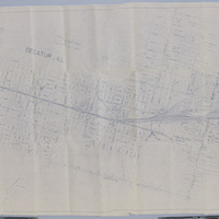
Wabash Railway Station Map: Lands, Tracks and Structures - Monroe St. to Wabash Yards (6/30/194?)
This station map shows the Wabash Railway tracks from Monroe St. to the Wabash yards.
Cincinnati, Indianapolis & Western RR Right of Way and Track Map - Fairview Ave to Franklin St. (6/30/1918 - Revised 6/7/1959)
This map shows the Cincinnati, Indianapolis & Western RR right of way and track from Fairview Ave. to Franklin St. The CI&W RR was operated by the Baltimore & Ohio Railroad Company. The map also shows the Wabash RR tracks and the St. Louis Bridge…
Wabash Railway Tracks - Mercer St. to N. Main St.

This map shows the Wabash Railway tracks from Mercer St. to N. Main St. It also shows the ITS tracks, businesses, and additions in the area. The map is not dated.
Wabash Railway Track - Monroe St. to Water St.

This map shows the Wabash track between Monroe St. and Water St.
Wabash Railroad Right of Way and Track Map - McClelland Ave. to Wabash Yards (6/18/1953)
This right of way and track map shows the Wabash track and yards in 1953. The map goes east from McClelland Ave. to the Wabash yards, and shows the streets and businesses in between. It also shows the Illinois Central Railroad track, the Illinois…
Wabash Railway Station Map: Lands, Tracks and Structures - N. Monroe St to Wabash Yards (6/30/1919)
This station map shows the Wabash Railway's lands, tracks, and structures between N. Monroe St. and the Wabash yards.
Station Maps of the Illinois Traction Inc., Operated by Illinois Terminal Company (12-31-1928)
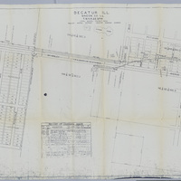
These station maps show the tracks of the Illinois Traction Inc. (operated by Illinois Terminal Company) running along McKinley Ave. There is also a list of changes made to the maps over the years.