
Browse Items (110 total)
- Collection: Railroad Map Collection #8.003
Sort by:
Right of Way and Track Map for Illinois Traction Inc., Operated by Illinois Terminal Company - Brush College Rd to 2 Miles East Across Lake Decatur (12/31/1928, revised 3/7/1933)
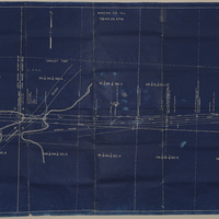
This map shows the right of way and track of the Illinois Traction Inc. from Brush College Rd. to 2 miles east across Lake Decatur. Illinois Traction Inc was operated by Illinois Terminal Company. The map also shows the Wabash Railway track.
Station Map of Illinois Central Railroad Showing Track Between N. Union St. and Oakland Ave. (7/14/1952)

This map shows the Illinois Central track between N. Union St. and Oakland Ave. It also shows where the ICRR crosses the Illinois Terminal System on Harrison St.
Station Maps of the Illinois Traction Inc., Operated by Illinois Terminal Company (12-31-1928)
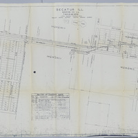
These station maps show the tracks of the Illinois Traction Inc. (operated by Illinois Terminal Company) running along McKinley Ave. There is also a list of changes made to the maps over the years.