
Browse Items (15 total)
Sort by:
Photos of North Monroe Street Subway Construction.

Photograph of building on the corner of N. Monroe St. and W. Eldorado in 1949. Photographs of the subway construction on N. Monroe St. by the Mueller Company Plant.
Photos of the North Monroe Street Subway Construction in 1942.

Photographs of the north Monroe Street Subway construction in 1942.
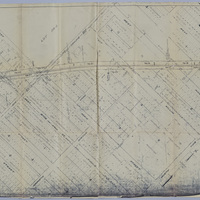
Wabash Railway Right of Way and Track Map - South of Rock Springs Rd. to Jackson St. (6/30/1919)

This right of way and track map shows the Wabash railroad track from south of Rock Springs Rd. to N. Jackson St.
Illinois Central Railroad Company Station Plat - Wilbur St. to N. Clinton St. (1/14/1911)

This is a station plat map of the Illinois Central Railroad Company between Wilbur St. and Clinton St.
Wabash Railway Station Map: Lands, Tracks, and Structures - Fairview Ave. to College St. (6/30/1938)

This station map shows the lands, tracks, and structures of the Wabash Railway between Fairview Ave. and College St.
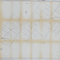
Wabash Railway Station Map: Lands, Tracks, & Structures - Fairview Ave. to Monroe St. (6/30/1919)
This map shows the Wabash Railway tracks from Fairview Ave. to Monroe St. in 1919. It also shows the businesses, additions, and streets between Fairview Ave. and Monroe St.
Cincinnati, Indianapolis & Western RR Right of Way and Track Map - Fairview Ave to Franklin St. (6/30/1918 - Revised 6/7/1959)
This map shows the Cincinnati, Indianapolis & Western RR right of way and track from Fairview Ave. to Franklin St. The CI&W RR was operated by the Baltimore & Ohio Railroad Company. The map also shows the Wabash RR tracks and the St. Louis Bridge…
Wabash Railway Station Map: Lands, Tracks, and Structures - W. Williams St. to W. Green St. (6/30/1938)

This station map shows the lands, tracks, and structures of the Wabash Railway between W. Williams St. and W. Green St. in 1938.
Wabash Railroad Right of Way and Track Map - McClelland Ave. to Wabash Yards (6/18/1953)
This right of way and track map shows the Wabash track and yards in 1953. The map goes east from McClelland Ave. to the Wabash yards, and shows the streets and businesses in between. It also shows the Illinois Central Railroad track, the Illinois…
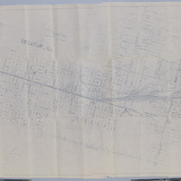
Wabash Railway Station Map: Lands, Tracks, and Structures - Fairview Park to N. Monroe St. (6/30/1919)
This station map shows the Wabash Railway's lands, tracks, and structures between Fairview Park and N. Monroe St. in 1919.