Browse Items (48 total)
- Tags: Sangamon River
Ralph Owen's Oral History - Transcription
Tags: 1987, Army, Betty Turnell, Chanute Air Field, Decatur High School, Decatur IL, Franklin Mall, Franklin Travel Agency, Gebhart family, history of Lake Shore Drive, Hobby House Toyland, ice cutting company, interview, January 1987, Lake Shore Club, Lake Shore Drive, Maffit St. Bridge, Mr. Allen, Mr. Maffit, OH42, oral history, Ralph Owen, recording, Sangamon River, sound recording, transcription, World War II, WWII
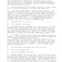
James E. Henson' Oral HIstory - Transcription
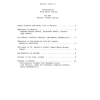
Tags: 1984, automobile, Bar Association, bar exam, Betty Turnell, Bloomington IL, childhood, circuit judge, Clara May Morthland Henson, County bridge, County building, county judge, Decatur Daily Review, Decatur High School, Decatur IL, Departmental School, divorce law, Donald W. Morthland, early Decatur, Emanual Rosenberg, Eva Josephine Young, Fairview Shopping Center, family law, family life, Faries Park, Henson Morthland and Bolin, Henson Morthland and Henson, Illinois Wesleyan University, Interurban, interview, Jackson Street School, James Atlas Henson, James E. Henson, James Millikin University, January 1984, Lake Decatur, law practice, Lost Bridge, Macon County Court, Macon County Jail, Macon County Sheriff, Maffitt Street Bridge, Martin E. Morthland, Masonic Temple, OH73, oral history, Ray's Bridge, recording, Richard F. Morthland, Riverside School, Sangamon River, sound recording, Staley Office Building, transcription
Photos of the Oklahoma Addition Slums
Tags: 1940's, Broadway, Oklahoma Addition, Sangamon River, Shacks, Slums, ST775, ST776, Streets
Photos of the Oklahoma Addition During May 1908 Flood
Tags: Broadway, Decatur IL., Dump, Flooding, Now MLK, Oklahoma Addition, Pollution, Sangamon River, sanitation, Slums, ST784, ST785, ST786, ST787, ST788, ST789, Streets
Wabash Railway Right of Way and Track Map - South of Rock Springs Rd. to Jackson St. (6/30/1919)
Tags: #8.003, 1919, 6/30/1919, Bridge, Bright St., Church St., collection, College St., Cottage Hill Ave., Decatur IL, Dunham St., Edward St., Fairview Ave., Fairview Rd., Haworth Ave., Home Ave., ISHRAB, ISHRAB-2017-25-125, Knights, Lincoln Park Dr., map, Maps, McClelland Ave., N. Franklin St., N. Jackson St., N. Main St., N. Mercer St., N. Monroe St., N. Oakland Ave., N. Pine St., N. Water St., Oakland Ct., Office of Chief Engineer, railroad, Railroad Ave., Railroad Map Collection, right of way, right of way and track map, Rock Springs Rd., S. Oakland Ave., Sangamon River, St. Louis Bridge, St. Louis Bridge Rd., State Route 48, State Rt. 48, Sunset Ave., Sycamore Ave., Track, Union St., University Ave., Van Dyke St., W. Cerro Gordo St., W. Decatur St., W. Eldorado St., W. Forest Ave., W. Green St., W. King St., W. Macon St., W. Main St., W. North St., W. William St., W. Wood St., Wabash, Wabash Railroad, Wabash Railway, Wabash RR, Willow Ave.
Cincinnati, Indianapolis, & Western RR Right of Way and Track Map - Taylorville Rd to Sangamon River (original 6/30/1918, revised 1/7/1955)
Tags: #8.003, 1/7/1955, 1918, 1955, 6/30/1918, B&O, Baltimore & Ohio Railroad Company, Cincinnati Indianapolis & Western RR, collection, Decatur IL, ISHRAB, ISHRAB-2017-25-10, ISHRAB-2017-25-4, Knights ILLS, map, Maps, Office of Valuation Engineer, public road, Railroad Map Collection, revised, right of way, right of way and track map, Sangamon River, Taylorville Road, Track
Partial Map of the Baltimore & Ohio Railroad Tracks over the Sangamon River at the Staley Bridge
Wabash Railway Right of Way and Track Map - From the Yards to the West of the Sangamon River (6/30/1919)
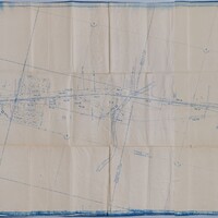
Tags: #8.003, 13th St., 14th St., 15th St., 18th St., 1919, 6/30/1919, additions, Camp and Emrich Addition of outlots, Camp and Emrich's 2nd Addition of outlots, Clarence Ave., collection, Decatur IL, Decatur Township, E. Division St., E. Grand Ave., E. Locust St., E. Logan St., E. Olive St., Hickory St., Illinois Traction System, ISHRAB, ISHRAB-2017-25-90, ITS, James St., Long Creek Township, map, Maps, Moser Road, Oakley Township, Office of Chief Engineer, Orchard St., Raceland Plat "C" in Plat "C", Raceland Plat "D" in Plat "A", Railroad Map Collection, right of way, right of way and tracks map, Sangamon River, Streets, Thomas Ave., Tracks, Wabash, Wabash Railroad, Wabash Railway, Wabash RR, Wabash yards, Westlake 2nd Addition of outlots, Westlake Addition of Outlots, Yards
Illinois Central Railroad Station Plat Map - Near the Sangamon River and City Waterworks (4/10/1951)
Cincinnati, Indianapolis & Western RR Right of Way and Track Map - Fairview Ave to Franklin St. (6/30/1918 - Revised 6/7/1959)
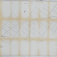
Tags: #8.003, 1918, 1959, 6/30/1918, 6/7/1959, B&O, Baltimore & Ohio Railroad Company, Bright St., Cerro Gordo St., Church St., CI&W RR, Cincinnati Indianapolis & Western RR, collection, College St., Cottage Hill Ave., Decatur IL, Edward St., Fairview Ave., Haworth Ave., Home Ave., ISHRAB, ISHRAB-2017-25-9, map, Maps, Mason St., N. Main St., N. Mercer St., N. Monroe St., N. Pine St., N. Water St., Office of Valuation Engineer, Railroad Map Collection, revised, right of way, right of way and track map, S. Franklin St., S. Oakland Ave., Sangamon River, St. Louis Bridge, Streets, Sunset Ave., Track, Union St., Van Dyke St., W. Decatur St., W. Eldorado St., W. Forest Ave., W. Green St., W. King St., W. Macon St., W. Main St., W. North St., W. William St., W. Wood St., Wabash, Wabash Railroad, Wabash Railway, Wabash RR
