
Browse Items (34 total)
Sort by:
Map of the Illinois Central Railroad Track from E. Sangamon St. to Division St. (1953)

This map shows the Illinois Central Railroad tracks from E. Sangamon St. to Division St., and includes the businesses
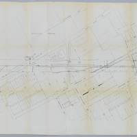
Pennsylvania Lines - Proposed Extension of Side Track for the Shellabarger Elevator Co. & Re-arrangement of Tracks in Marietta St. Yard (12/6/1919)

This map shows the proposed side track extension of the Pennsylvania Lines for the Shellabarger Elevator Co., and the re-arrangement of the Marietta St. yards.
Illinois Central Railroad Station Plat Map - Ruth St. to Wood St. (4/10/1951)
This map shows the Illinois Central Railroad track from Ruth St. to Wood St., and includes all the streets, additions, and buinesses in between.
Partial Map of the Illinois Central Railroad Belt Line along W. McKinley St. (N/D)

This map shows the Illinois Central Railroad belt line along W. McKinley St. down to the PD&E Railway at Harrison Ave. This belt line connected the Peoria branch of the ICRR to the main line. The date is unknown on this map. This map attaches to…