
Browse Items (21 total)
Sort by:
Illinois Traction Inc Right of Way and Track Map - Springfield Road to Summit Ave. (12/31/1928)
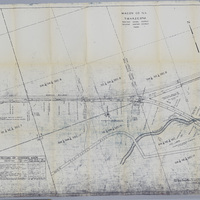
This right of way and track map shows the Illinois Traction Inc. tracks heading East into Decatur past Stephen's Creek. It also shows the Wabash Railway track running parallel to the ITS track. Illinois Traction Inc. was operated by the Illinois…
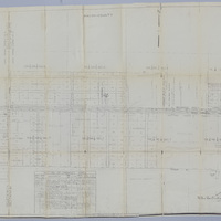
Illinois Central Railroad Right of Way and Track Map - E. North St. to E. Harrison St. (12/31/1935)
This is a map of the Illinois Central Railroad right of way and tracks between E. North St. and E. Harrison St. It also shows the Wabash yards and tracks. The map was last revised on 12/31/1935.
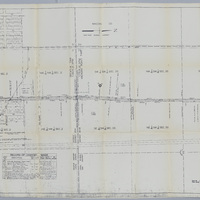
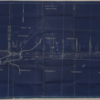
Wabash Railroad Right of Way and Track Map - 27th St. Through Lake Decatur (7/1/1953)
This right of way and track map shows the Wabash Railway tracks going east from 27th St. over Lake Decatur.
Illinois Traction Inc. Right of Way and Track Map - Running North from Race Track (12/31/1928)
This is a right of way and track map for the Illinois Traction, Inc, which was operated by the Illinois Terminal Company. The map shows the track running north from the race track at Broadway St. and Kenwood Ave. The Illinois Central Railroad…
Illinois Traction Inc. Right of Way and Track Map - E. Garfield Ave. (12/31/1928, revised 3/9/1945)
This is an Illinois Traction Inc. right of way and track map. The map shows the track running along E. Garfield Ave through Brush College Road. Illinois Traction, Inc. was operated by Illinois Terminal Company.
Right of Way and Track Map for Illinois Traction Inc., Operated by Illinois Terminal Company - Brush College Rd to 2 Miles East Across Lake Decatur (12/31/1928, revised 3/7/1933)
This map shows the right of way and track of the Illinois Traction Inc. from Brush College Rd. to 2 miles east across Lake Decatur. Illinois Traction Inc was operated by Illinois Terminal Company. The map also shows the Wabash Railway track.