
Browse Items (98 total)
Sort by:
Illinois Central Railroad Right of Way and Track Map - E. North St. to E. Harrison St. (12/31/1935)
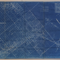
This is a map of the Illinois Central Railroad right of way and tracks between E. North St. and E. Harrison St. It also shows the Wabash yards and tracks. The map was last revised on 12/31/1935.
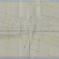
Illinois Central Railroad Station Plat Map - Tait Ave. - Division St. (9/15/1952)

This Illinois Central Railroad station plat map shows the yards, tracks, streets, and businesses between Tait Ave. and Division St. in 1952.
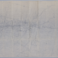
Wabash Railway Station Map: Lands, Tracks, and Structures - Thomas St. to James St. (6/30/1950?)
This Wabash Railway station map shows lands, tracks, and structures from Thomas St. to James St. in the 1950s.
Wabash Railroad Right of Way and Track Map - 27th St. Through Lake Decatur (7/1/1953)
This right of way and track map shows the Wabash Railway tracks going east from 27th St. over Lake Decatur.
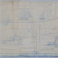
Wabash Railway Station Map: Lands, Tracks, and Structures - Wabash Yards (6/30/1919)
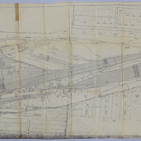
This Wabash Railway station map shows the lands, tracks, and structures in and around the Wabash yards.
Wabash Railway - Pipe and Sewer Lines (5/25/1920)
This map shows the pipe and sewer lines in the Wabash RR yards.
Wabash Railroad Station Map: Tracks and Structures - Wabash Yards (3/28/1952)
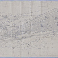
This is a station map of the tracks and structures at the Wabash RR yards.
Partial Map of the Wabash Railroad Office Building - Showing Jordan St.

This is a partial map of Jordan St. in Decatur, IL. On the back of the map, it says that this partial map is part of a map of the Wabash RR's office building.
Illinois Central Railroad Track Map - Harrison Ave. and Graceland Ave. (1908)

This is a map of the Illinois Central Railroad Peoria Division track crossing Harrison Ave. and Graceland Ave.
Pennsylvania Railroad Company Side Track Agreement with McClelland Grocer Co., Nafziger Baking Co., James M. Allen, & Grace S. Allen (2/18/1926)

This is the side track agreement between Pennsylvania Railroad Company, McClelland Grocer Co., Nafziger Baking Co., James M. Allen, and Grace S. Allen. It includes a map of the side track and the signed agreement.