
Browse Items (134 total)
- Collection: Photo File: Streets
Sort by:
Photo of N. Fairview at King St.

Photograph of cars and houses on N. Fairview Ave. at King St., Decatur, IL.
Photo of Oak Grove Road

Photograph of Oak Grove Road. Photo ran Review 10/8/1911. Road located north of Fairview Park.
Photo of Old Automobiles on E. Packard St., Decatur, IL.

Photograph of old automobiles parked on E. Packard St., A & P Grocery was located at 1360 E. Packard.
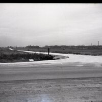
Photo of Parking Garage located at 360 E. Wood Street and Franklin.

Photograph of 360 E. Wood Street Parking Garage, taken by Don Baker, 1996.
Photo of Paving Machine on East Hickory Street.

Photograph of Paving Equipment on East Hickory Street at Warren. "Paving work halted in late December, 1909 when snow blanketed East Hickory Street at Warren Street. Travel on the frozen ground in winter in those days was much better than the…
Photo of Sewer along Cantrell Street, Decatur, IL.

Photograph of Sewers along Cantrell Street, Decatur, IL. Photograph of the collapsed section of sewer along Cantrell Street east of Franklin. Photographs of Cantrell and Broadway Streets.
Photo of William Street at Edward Street.

Photograph of William Street at Edward Street, brick or block.

Photograph of East Prairie St.

Photograph of a horse being driven along East Prairie St. in Decatur around 1900 expresses his dislike of a new horseless carriage chugging along the corner. This picture of old Decatur was made from one of a number of glass negatives found in the…