
Browse Items (17 total)
Sort by:
Wabash Railway Station Map: Lands, Tracks and Structures - Monroe St. to Wabash Yards (6/30/194?)
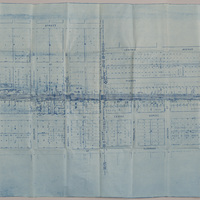
This station map shows the Wabash Railway tracks from Monroe St. to the Wabash yards.
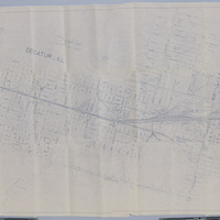
Illinois Central Railroad Station Plat Map - Decatur St. to Cerro Gordo St. (9/11/195?, revised 11/30/1955)

This map shows the Illinois Central Railroad tracks from Decatur St. to Cerro Gordo St. The map shows the industries, additions, and streets between Decatur St. and Cerro Gordo St.
Illinois Traction, Inc. Right of Way and Track Map - North Along Broadway St. (12/31/1928)

This right of way and track map shows the Illinois Traction, Inc. and Illinois Central Railroad tracks north of the race track along Broadway St. Illinois Traction, Inc. was operated by the Illinois Terminal Company.
Illinois Traction, Inc. Station Map - Water St. to Jasper St. (12/31/1928, revised 2/25/1945)

This station map shows the Illinois Traction, Inc. and Illinois Central Railroad tracks between Water St. and Jasper St. The map was originally created on 12/31/1928, and last revised on 2/25/1945. The map shows Leader Iron Works, and the ITS' car…
Wabash Railway Track - Monroe St. to Water St.

This map shows the Wabash track between Monroe St. and Water St.
Wabash Railroad Right of Way and Track Map - McClelland Ave. to Wabash Yards (6/18/1953)
This right of way and track map shows the Wabash track and yards in 1953. The map goes east from McClelland Ave. to the Wabash yards, and shows the streets and businesses in between. It also shows the Illinois Central Railroad track, the Illinois…
Illinois Traction Station Map - Water St. to Illinois Central Railroad Track (12/31/1928, revised 1/16/1958)

This is a station map for Illinois Traction Inc, operated by Illinois Terminal Company. It shows the track between Water St. and the Illinois Central Railroad track.
Illinois Central Railroad Station Plat Map - Decatur St. to Cerro Gordo St. (9/11/1951)

This is a station plat map for Illinois Central Railroad showing the tracks from Decatur St. to Cerro Gordo St. It also includes the streets and businesses between those two streets, and the Wabash RR tracks.
Photo of K's Merchandise Building Downtown

Photograph of the K's Merchandise Building located on Water Street, Decatur, IL.
Photographs of South Water St.

Photographs of House on S. Water Street taken in 1955. Two photographs of South Water St. One, taken in 1895 looking North from the Millikin Bank on South Water St. and the other taken at South Water and Wood Streets in August 1996.