
Browse Items (68 total)
Sort by:
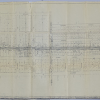
Illinois Traction, Inc. Right of Way and Track Map - N. Main St. to N. Woodford St. (12/31/1928)
This right of way and track map shows the Illinois Traction and Illinois Central Railroad tracks between N. Main St. and Woodford St. Illinois Traction, Inc. was operated by the Illinois Terminal Company.
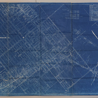
Illinois Central Railroad Plat of Portion of P.D. & E Old Main (5/11/1912)

This map shows the portion of the Peoria, Decatur & Evansville RR from W. Grand Ave to Wabash Ave. This line was operated by the Illinois Central Railroad in 1912.
Illinois Central Railroad - Showing Sewers & Pavement at Prairie St. Subway (5/20/1916)

This drawing shows the Illinois Central Railroad Prairie St. subway's sewers and pavement in 1916.
Wabash Railroad Right of Way and Track Map - McClelland Ave. to Wabash Yards (6/18/1953)
This right of way and track map shows the Wabash track and yards in 1953. The map goes east from McClelland Ave. to the Wabash yards, and shows the streets and businesses in between. It also shows the Illinois Central Railroad track, the Illinois…
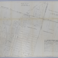
Illinois Traction Inc. Station Map - McClelland Ave. to N. Monroe St. (12/31/1928)
This station map shows the Illinois Traction Inc. tracks from McClelland Ave. to N. Monroe St. in 1928. It also shows the Wabash and ICRR tracks. Illinois Traction Inc. was operated by Illinois Terminal Company.
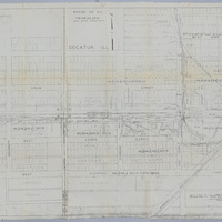
Wabash Railway Station Map: Lands, Tracks, and Structures - Fairview Park to N. Monroe St. (6/30/1919)
This station map shows the Wabash Railway's lands, tracks, and structures between Fairview Park and N. Monroe St. in 1919.
Wabash Railway Station Map: Lands, Tracks and Structures - N. Monroe St to Wabash Yards (6/30/1919)
This station map shows the Wabash Railway's lands, tracks, and structures between N. Monroe St. and the Wabash yards.
Illinois Central Railroad Proposed Subway at S. Main St. - General Filing Plan (9/20/1930)

This is the general filing plan for the ICRR's proposed subway on S. Main St. This subway was approved and later constructed.
Illinois Central Railroad - Curtis St. to SBI Route 48 & 121 (4/3/1935)

This is a map of the Illinois Central Railroad from Curtis St. to SBI Route 48 & 121 (now Pershing Rd.).
Illinois Central Railroad Right of Way and Track Map - E. North St. to E. Harrison St. (12/31/1935)
This is a map of the Illinois Central Railroad right of way and tracks between E. North St. and E. Harrison St. It also shows the Wabash yards and tracks. The map was last revised on 12/31/1935.