
Browse Items (24 total)
Sort by:
Wabash Railway Station Map: Lands, Tracks and Structures - N. Monroe St to Wabash Yards (6/30/1919)
This station map shows the Wabash Railway's lands, tracks, and structures between N. Monroe St. and the Wabash yards.
Wabash Railway Right of Way and Track Map - South of Rock Springs Rd. to Jackson St. (6/30/1919)

This right of way and track map shows the Wabash railroad track from south of Rock Springs Rd. to N. Jackson St.
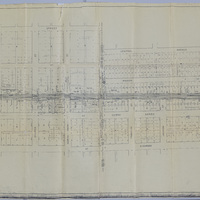
Station Maps of the Illinois Traction Inc., Operated by Illinois Terminal Company (12-31-1928)
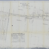
These station maps show the tracks of the Illinois Traction Inc. (operated by Illinois Terminal Company) running along McKinley Ave. There is also a list of changes made to the maps over the years.
Profile of the Illinois Traction Inc. Decatur Belt Line (6/17/1925)

This shows the profile of the Decatur belt line of the Illinois Traction Inc. The profile shows the elevation of the tracks, what streets it crossed, and what other railroads it crossed.
Photos of the J. C. Penney Store and Staff

Photograph of the J. C. Penney Co. Store and street. Photograph of the J. C. Penney Staff wearing striped jackets. Photograph of the J. C. Penney Co. store.
Photos of J. C. Penny Store 1940's

Photographs of the J. C. Penny Store located on N. Water St., Decatur, IL. during the 1940's.
Photos of Gospel Center location of William "Billy" Sunday Revival.

Photograph of the Gospel Center located on N. Water St. location of a revival by Billy Sunday. Photograph of Decatur Tabernacle building location of revival by Billy Sunday. "Sunday, William 'Billy'--Decatur Tabernacle. Evangelist Billy Sunday…
Photos of Businesses on N. Water St., Decatur, IL.

Photograph of businesses on the 200 block of N. Water Street, Decatur, IL. about 1910. Aerial photograph of the 300 block of N. Water Street, July 1930.
Photographs of N. Water Street Street Scenes 1940's.

Photographs of N. Water Street Scenes in the 1940's.